LifeScienceHistory.com - Check us out on Instagram
Take Your Next Career Step with Lundback
Geography & Climate
Industry Overview |
Economy/Cost of Living
Education |
Recreation & Entertainment |
Transportation
History |
Suggested Reading List
Idaho is located in the northwestern region of the United States. It contains 82,751 square miles (214,232 square kilometers or 21,423,249 hectares) of land, and 823 square miles (2,131 square kilometers or 213,065 hectares) covered by water. The state’s total area of 83,574 square miles (216,363 square kilometers or 21,636,314 hectares) makes it the 14th largest among the United States. Idaho is bordered to the north by the country of Canada, to the east by Montana and Wyoming, to the south by Utah and Nevada, and to the west by Washington and Oregon.
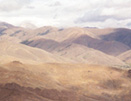
Idaho’s shape is defined by a narrow Panhandle in the northern portion of the state, and a wider base. The state contains a stunningly varied topography of rugged mountain ranges, canyons and river valleys, and plateaus. Broad forests and many lakes add to the magnificent natural beauty of the Gem State.
Idaho is divided geographically into three regions: the Rocky Mountains, Columbia Plateau, and Basin and Ridge Region. The Rocky Mountains reign over much of the state; this area stretches from the Panhandle to Wyoming’s border. Other important mountain ranges in the state include the Coeur d’Alene Mountains, the Lost River Range, the Clearwater Mountains, the Bitterroots, the Sawtooth Mountains, the Blackfoot Mountains, the Salmon River Mountains, the Lemhi Range, and the Seven Devils Mountains. Idaho contains many peaks that rise over 10,000 feet (3,048 meters) above sea level. The Gem State’s highest point is Borah Peak on Mount Borah, at 12,662 feet (3,859 meters) above sea level.
The Columbia Plateau extends from Washington State into Idaho and consists of the Snake River Plain, a region formed by ancient lava flows. In the Basin and Range Region contains valleys and plateaus.
Important rivers in the Gem State include the Snake, Kootenai, Coeur d’Alene, St. Joe, and St. Maries Rivers. Shoshone Falls, on the Snake River, falls 212 feet (64.6 meters), which ranks it higher than the Niagara Falls. The Snake River also boasts the deepest canyon in the nation, Hells Canyon.
Idaho’s climate is variable, and is influenced greatly by the Pacific Ocean. The state has four distinct seasons; however some regions reach spring and winter at different times based on terrain. The eastern portion of the state tends to be more extreme, and is influenced by high altitudes. Precipitation is greater in the northern portion in the state than elsewhere, with approximately 30 inches (76.2 centimeters) annually, whereas the southern portion is warmer and drier, with about 13 inches (33.02 centimeters) annually; the mountains receive a significant amount of snow. The Gem State does experience thunderstorms, which are less severe than most regions of the nation. Average temperatures in the city of Boise are 29 degrees F (-1.7 degrees C) in January and 74 degrees F (23.3 degrees C) in July.
Related Resources:
Back to Destination Idaho